


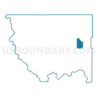
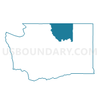
Aeneas Voting District, Okanogan County, Washington
About
Outline

Summary
| Unique Area Identifier | 687737 |
| Name | Aeneas Voting District |
| County | Okanogan County |
| State | Washington |
| Area (square miles) | 52.14 |
| Land Area (square miles) | 52.14 |
| Water Area (square miles) | 0.00 |
| % of Land Area | 100.00 |
| % of Water Area | 0.00 |
| Latitude of the Internal Point | 48.54705040 |
| Longtitude of the Internal Point | -119.13677550 |
Maps

Graphs
Select a template below for downloading or customizing gragh for Aeneas Voting District, Okanogan County, Washington


Neighbors
Neighoring Voting District (by Name) Neighboring Voting District on the Map
- Anglin Voting District, Okanogan County, WA
- Cape Labelle Voting District, Okanogan County, WA
- Chewiliken Voting District, Okanogan County, WA
- Leese Voting District, Okanogan County, WA
- Omak Mtn Voting District, Okanogan County, WA
- San Poil Voting District, Okanogan County, WA
- Sourdough Voting District, Okanogan County, WA
- Tunk Creek Voting District, Okanogan County, WA
Top 10 Neighboring County Subdivision (by Population) Neighboring County Subdivision on the Map
Top 10 Neighboring Unified School District (by Population) Neighboring Unified School District on the Map
- Omak School District, WA (10,481)
- Tonasket School District, WA (6,638)
- Nespelem School District, WA (1,354)
Top 10 Neighboring State Legislative District Lower Chamber (by Population) Neighboring State Legislative District Lower Chamber on the Map
Top 10 Neighboring State Legislative District Upper Chamber (by Population) Neighboring State Legislative District Upper Chamber on the Map
Top 10 Neighboring 111th Congressional District (by Population) Neighboring 111th Congressional District on the Map
Top 10 Neighboring Census Tract (by Population) Neighboring Census Tract on the Map
- Census Tract 9703, Okanogan County, WA (7,308)
- Census Tract 9402, Okanogan County, WA (3,129)
- Census Tract 9401, Okanogan County, WA (2,825)